Weather and Climate Info:
Summer (April – June):
Accessibility
he trail is dry and accessible for the trekkers.
Weather Conditions
The weather is mild and the temperature is favourable, ranging from2°C to 20°C.
Overview
Best time for trekking and capturing nature’s beauty.
Monsoon (July – September):
Accessibility
The trail is accessible by slippery due to excessive rainfall.
Weather Conditions
Cloudy throughout the day, causing low visibility and temperatures ranging from 4°C to 18°C.
Overview
Landslides are common, and leeches are present in the forest areas. Should be highly experienced for the monsoon season.
Autumn (October – November):
Accessibility
The trail is accessible, and the environment is fresh after the monsoon.
Weather Conditions
Clear sky and crisp landscape view. The temperature can be cold, especially during the night, which ranges from -2°C to 15°C.
Overview
The landscapes look different from the previous seasons as the meadows turn golden brown, which adds more warmth to the overall trekking experience.
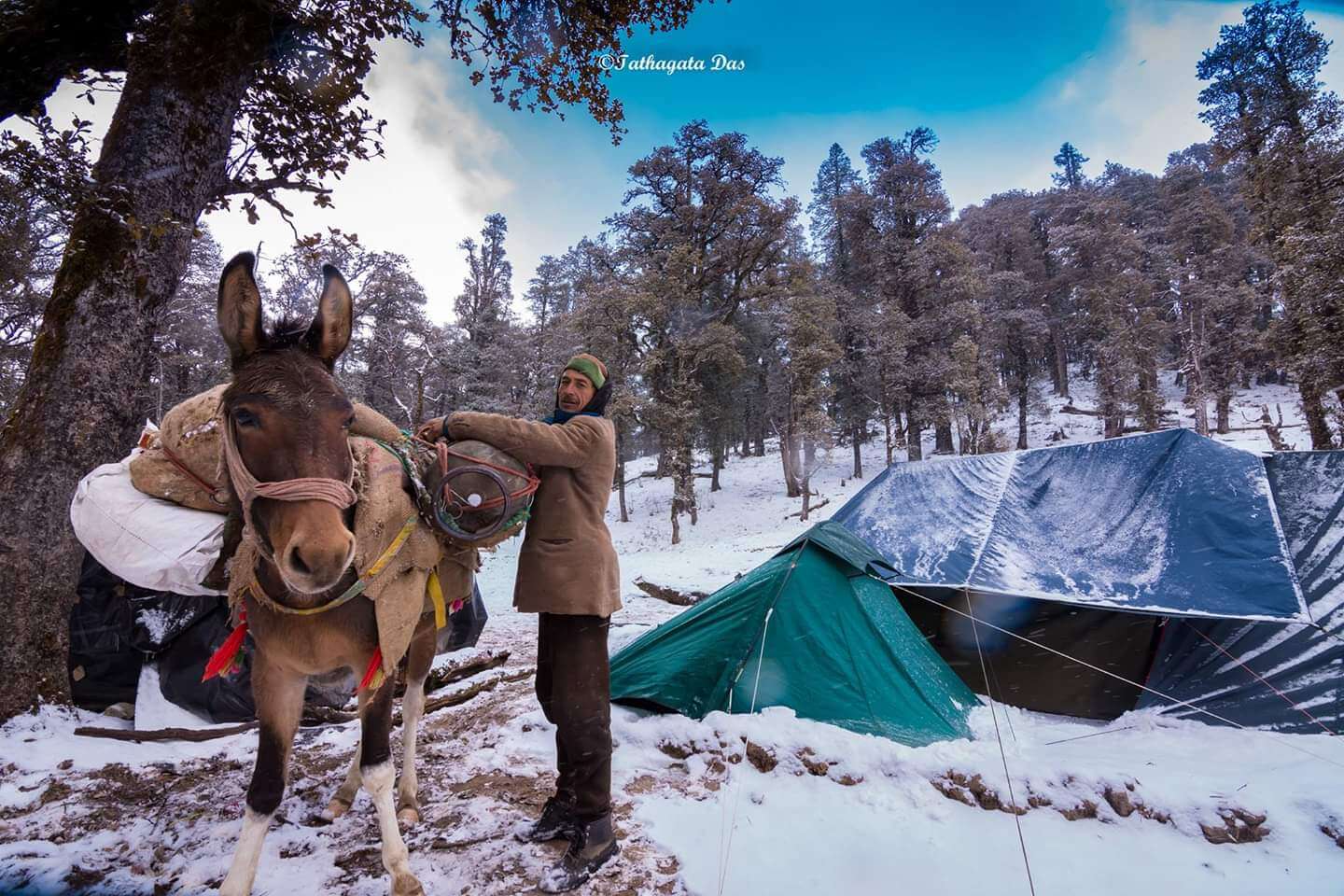
Winter (December – March):
Accessibility
The trail is inaccessible, and the trek is officially closed.
Weather Conditions
Unfavourable weather and freezing temperatures ranging from –10°C to 5°C.
Overview
The trail is under many layers of snow, and there is a risk of avalanches in the entire area. The Fachukandi Pass Trek is closed.
Temperature Overview
Summer (April to June):
Daytime temperatures: 20°C
Nighttime temperatures: 2°C
Autumn (October to November):
Day temperatures:
15°C
Night temperatures:
-2°C
Winter (December to March):
Daytime temperatures: 5°C
Nighttime temperatures: -10°C
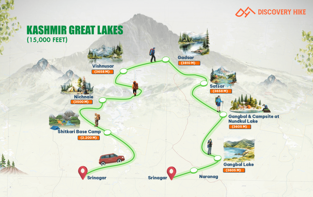
Mountain Ranges, River Valley & Lake:
Mountain Ranges
Swargarohini Range
These peaks have high mythological value among the locals as the “Pandavas” are said to have ascended to heaven from the Swargarohini Peaks. The Swargarohini I, II, III, and IV peaks form the major part of the mountain range and can be observed from different parts of the trail.
Bandarpoonch Range
The primary peaks of this mountain range are Bandarpoonch I and Kalanag. It is visible from the Pushtara Meadows, Kedarkanta Summit and Fachukandi Pass as well.
River Valley
Tons River Valley
Sankri is one of the villages which is part of the Valley region of the Tons River. The river has formed due to the melting of the Bandarpoonch Glacier. The Tons can also be found along the way to Dehradun. The Tons River Valley is home to many varieties of flowers and wild animals. Many Garhwali villages, including Sankri, depend on the Tons River for meeting their water requirements.
Rupin-Supin River Valleys
The Supin River is a tributary of the Tons River and flows in the region of Sankri and Taluka. It can be observed by the trekkers during the initial days of the Fachukandi Pass Trek. The Rupin River is not part of the trek, but can be observed from the higher regions and regions. The Rupin River Valley separates the Rupin and the Supin rivers.
Lake
Saru Tal
The Saru Tal lake is located just before the Summit of the Fachukandi Pass. It is a beautiful alpine lake with ridges on one side and towering peaks on the other side. It is an extremely good place to meditate and let go of the outside world for a while. The Saru Tal campsite is the most peaceful among all the campsites of the Fachukandi Pass Trek.
Geographical Highlights
Glacier
Bandarpoonch Glacier
The Bandarpoonch Glacier is located in the northern part of the trail and is a source for many rivers in the Sankri region. The primary river originating from this glacier is the Tons Glacier.
Saru Tal Glacial Basin
The Har Ki Dun Valley is one of the most important parts of the trek. It is surrounded by the Swargarohini Peaks, which look breathtaking. The entire grassland is filled with colourful wildflowers, which attract many varieties of insects and birds. As you descend towards Himachal, the Bonga meadows welcome you. The trekkers often rest here after the strenuous crossing of the Borasu Pass.
High-altitude meadows
Pushtara Meadow
The Pushtara Meadows form large grasslands at a high altitude. The views of the Swargarohini and Bandarpoonch ranges surround the entire region. The shepherds use these meadows for grazing their cattle. Herds of cattle across the Pushtara Meadows give an amazing opportunity for photography. The blooming of the wild flowers during the summer and monsoon adds a variety of colours to the meadows. The Pushtara Meadows are an amazing location for camping and appreciating the beauty of nature. Bird watching and Star gazing are also best suited to this location.
Passes
Fachukandi Pass
The primary Pass of the trail is the Fachukandi Pass, which connects the Supin valley to the Yamunotri Valley. The pass is surrounded by the Himalayan ranges with snow-covered peaks. The Fachukandi Pass is covered by snow throughout the year, especially during the early months of the year. Therefore, follow the Discovery Hike Team Leaders during the ascent for guidance and safety.
Flora and Fauna:
Flora
Forests
The dense coniferous forests across the trail are home to many trees like pine, fir, birch, maple, chestnut, deodar and many other trees. The forests provide protection, shelter, food and many commercial opportunities to the Garhwali people of Sankri and surrounding villages. The forests also have a large number of animals, which can make the journey quite exciting for the trekkers.
Floral Diversity
The wildflowers like poppies, silvery Rupin, wild primula and bloodroot are common in the meadows and also in the forest areas. Red, pink and white coloured Rhododendrons can be witnessed during the summer and pre-monsoon months. Brahma Kamal, the State Flower of Uttarakhand, can be seen. It is known for blooming during the night.
Vegetation
Himalayan Raspberries, Berberis, fern and other plants can be found in the lower parts of the trek. Mosses and lichens can be seen in the higher altitudes because of low oxygen and extremely cold temperatures.
Fauna
Mammals
The Himalayan Black Bear is common in the forest regions and lower sections of the trail,while the alpine meadows at higher altitudes are home to the Brown Bear. Snow leopards can be seen near the glacial moraines and ridges. Although they are a rare sight but the trekkers may witness snow leopards hunting the blue sheep, near the rocky sections. Musk Deer, langurs and red foxes are other mammals that can be observed in the Fachukandi Pass Trek.
Birds
The Golden Eagle is the apex predator in the entire region among the birds. It is famous for its large wingspan and size. The Himalayan Griffin Vulture is also one of the famous birds and can be found in the higher parts of the trail. The State Bird of Uttarakhand, the Himalayan Monal, is also common in this region. It is characterised by its vibrancy and iridescence. Other birds like Bearded Vulture, Cheer Pheasant and Snow Partridges can also be seen in the meadows and snowlines of the Fachukandi Pass.
Photography Tips
Golden Hours for Lighting:
Tip:Leverage the stunning lighting conditions during the golden hours – early morning and late afternoon. Capture soft and golden light that enhances the beauty of the landscape. Avoid midday when the light can be harsh, but it can also create compelling contrasts in the rugged terrain.
Flora and Fauna Focus:
Tip: Explore the rich biodiversity of Sankri. Capture vibrant rhododendrons in spring, lush greenery in monsoon, and snow-covered trees in winter. Use a zoom lens for wildlife shots, maintaining a safe distance to avoid disturbing the animals.
Landscape Photography Essentials:
Tip:The panoramic views of the Himalayas are breathtaking. Keep a wide-angle lens handy to capture the vast landscape. Add depth and scale by incorporating elements like trekkers or tents in the foreground.
Experiment with Perspectives:
Tip:Vary your angles and perspectives for unique shots. A low-angle shot of a trail leading into the mountains can add depth and intrigue to your photos. Experimentation can lead to captivating compositions.
Rule of Thirds:
Tip: Compose balanced and interesting shots using the rule of thirds. Divide your frame into nine equal segments and place key elements along these lines or their intersections. This simple rule can significantly enhance the visual appeal of your photographs.
Capture Local Culture:
Tip: As the Fachukandi Pass Trek passes through quaint villages, document local architecture, people, and daily life. Seek permission before photographing individuals to respect their privacy and cultural norms.
Night Sky Photography:
Tip:Utilise the clear skies at high altitudes for astrophotography. Set up a tripod and use long exposure settings to capture the stars, and potentially the Milky Way. The serene nights in the Himalayas offer a canvas for stunning celestial shots.
Be Weather Prepared:
Tip: The Himalayan weather is unpredictable. Protect your camera equipment from rain and snow using weather-resistant gear. Keep batteries warm in cold weather to prevent quick drainage. Consider using lens hoods and covers for additional protection.
Travel Light:
Tip:Prioritise essential gear for high-altitude trekking. Minimise equipment to reduce the weight you carry. A lightweight and versatile camera setup will ensure you are agile and ready to capture spontaneous moments.
Respect the Environment:
Tip:Be mindful of your surroundings. Avoid damaging the natural environment or disturbing wildlife while capturing your shots. Leave no trace and follow the principles of responsible trekking and photography.
Bonus Tip – Patience is Key:
Tip:Sometimes, waiting for the right moment, light, or movement can make a significant difference in capturing a memorable photograph. Practice patience during your trek, and you might be rewarded with extraordinary shots that tell a unique story of your Fachukandi Pass adventure.
Things to Carry:
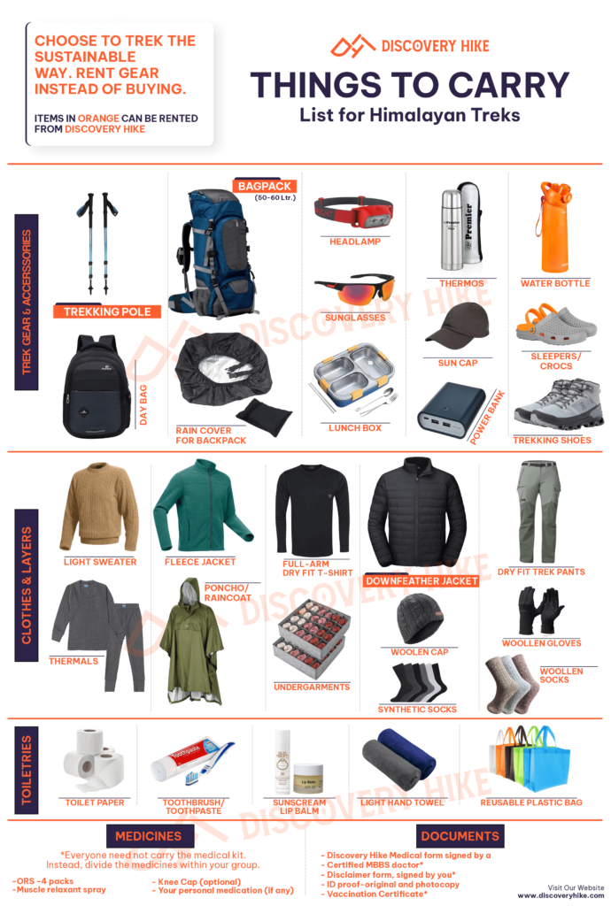
Hiking Shoes
- Type: We recommend that you look for water-resistant shoes with a deep yet flexible sole to sustain on Himalayan terrains.
Note: Dynamic rough terrains hold uncertain threats. The pair of shoes that has the advantage of overcoming those threats will help you to maintain your confidence in balancing.
Backpack
- Type: It purely depends on the kind of Trek you plan.
- (15-20) litres will be ideal for short treks of (1-3) days.
- (40-60) litres will be ideal for long treks of (3 – 10) days.
Note: A backpack comes under very essential for the activity like trekking. You will have a requirement of your Backpack throughout the journey for your belongings and all the essentials you need. We recommend you test the bag and choose it according to your height, the Trek where you are taking it & comfort it provides.
Daypack
- Type: A (10 – 15) litres waterproof daypack is all you need to have with you for the Summit.
Note: Your Daypack will be for those Summit days and shorter days when you just need your essentials (wallet, small water bottle, sunglass, power bank, etc.) with you.
Clothing
- Collared T-shirts – Carrying 2 – 3 units of collared T-shirts will be ideal. The collar will help you to keep your neck away from direct sunlight and not too exposed to the Sun and getting sunburnt.
- Padded Jacket – Ensure that the jacket is wind-resistant & capable of keeping you warm at -10 °C to -12 °C temperature.
- Fleece Jacket – Fleece jackets are made of very soft and cozy material. It helps you to maintain a comfortable body temperature. Keep 2 Fleece Jackets with you.
- Thermals – You will have a requirement of only 1 pair of this in the Winter, For Summer it could be under consideration. It is made of pure cotton and designed in such a way that body heat is blocked between its layers. It will keep you warm during the nights when the temperature falls.
- Trek Pants – You will have a requirement of 2 units of Trekking Pants with you always. Between them, one must be convertible. Ensure it is made of Cotton or windproof light material & provides maximum durable comfort.
- Sun Caps –The Sunlight might be harsh at higher Altitudes and the direct exposure of sunlight to your head is harmful to your skin. Carry Sun Caps to keep your head cool.
- Woolen Caps – You will need woolen caps during the nights to keep your ears and head warm from the very cold breeze.
- Waterproof Gloves – You will require waterproof gloves for cold and wet sections of the Trek. Always keep your hands clean & warm, and avoid letting your hands wet to get the supporting grip and balance.
Trek Accessories
- Trekking Pole: The Trekking/Hiking Pole saves 60% of your energy for conquering a steep slope at a higher altitude. It is advisable to carry a trekking pole with you for the treks.
- Head-lamp or Torch: A head-lamp is another important thing that also comes under mandatory items for our Treks. It will help you to deal with the dark. Headlamps become more effective to walk in dark cold weather without approaching through your hand. Featured Torch is also ok for uphill.
Daily essentials
- Toiletries: We recommend you carry all your Toiletries essentials and all other personal belongings by yourself to avoid borrowing. Here are some items you could take- tooth-cleaning paste, dental brush, lip moisturizer, skin hydrating cream, facial cleanser, a range of vital creams and items, bathroom tissue/toilet paper, menstrual pads, along with other important personal care items like shampoo, conditioner, deodorant, and shaving supplies.
- Containers & Vessels: It’s advisable to bring your water containers; we recommend two bottles each with a capacity of 1 litre. Additionally, for both ease and hygiene reasons, please carry your food containers to use for the meals we supply. The metal bottle comes in handy for hot water served in the camps.
- Recommended Medicines: Gauze 1 small roll, Dexamethasone one strip, Nifedipine 5 tablets, Band aid 10 strips, Avomine 4 tablets (motion sickness), Avil 25mg 4 tablets (allergies), Combiflam 4 tablets (Pain killer), Crepe bandage 3 to 5 meters, Disprin 6 tablets (headache), Crocin 6 tablets (fever), Digene 10 tablets (acidity), Omez/ Rantadine 10 tablets (antacids), Norflox TZ & Lomofen 6 tablets each (diarrhea), Diamox 10 tablets (to prevent AMS), Cotton 1 small roll
Essential Documents Required:
For the Fachukandi Pass Trek, you must bring specific documents and submit them to the trek leader at the base camp. These include a copy of the Disclaimer, along with one photocopy and the original of a government-issued photo ID. Additionally, a doctor’s medical certificate confirming your fitness for high-altitude conditions is required.
Risks and Precautions:
Here are the risks or challenges you might face on the Fachukandi Pass Trek.
Risk of Slip/Skid:
Nature of Risk:The trail, particularly in winter (December and January), may be scattered with black ice, leading to a risk of slipping or skidding. Additionally, the unpredictable Himalayan weather adds to the challenge.
Safety Precautions:
• Briefing session at the base camp regarding slip/skid risks.
• You will get a trained trek leader’s guidance on maintaining balance and proper use of trekking poles.
• Provision of crampons by Discovery Hike for snow-filled trails, reducing skidding risk by up to 95%.
• Continuous awareness communication from the trek leader during the trek.
• Choosing trekking shoes with a good grip is crucial.
High Altitude Risks:
Nature of Risk: Ascending from 6,400 feet to 11,500 feet over 4-5 days may lead to Acute Mountain Sickness (AMS), High Altitude Pulmonary Oedema (HAPE), and High-Altitude Cerebral Oedema (HACE), especially at higher camps.
Safety Precautions:
• Start DIAMOX from the first day to reduce AMS risk.
• Trained leaders are recognizing AMS symptoms and equipped with a high-altitude medical kit.
• Oxygen cylinders are available for safety.
• Immediate descent if conditions worsen.
Dealing with Blisters and Cramps:
Nature of Risk: Blisters, cuts, and cramps can occur on uneven trails.
Safety Precautions:
• Trekkers to inform the trek leader promptly.
• Well-fitting, breathable trekking shoes are recommended.
• Treatment kit with trek leader and application of cramp spray for leg cramps.
Weather Risks at High Altitude:
Nature of Risk: Unpredictable weather, particularly in the Himalayas, can worsen quickly.
Safety Precautions:
• Trek leader’s decision on continuing or waiting for better weather.
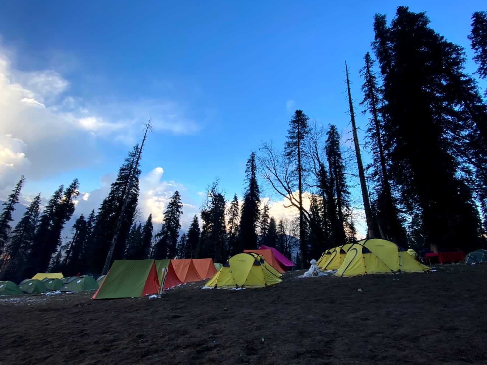
• Provision of all-weather tents to cope with different weather challenges.
Communication Risks:
Nature of Risk: Communication signals weaken and may be lost completely at higher altitudes.
Safety Precautions:
• Use of walkie-talkies for alternative communication between different campsites.
Emergency/Immediate Rescue:
Nature of Risk: Severe health issues or emergencies may necessitate immediate rescue.
Safety Precautions:
• Quick utilization of resources like porters and mules for rescue. *Rescue cost is not included in the package.
• Stand by team at different campsites for assistance.
• Airlifts are arranged in acute cases. *The cost of airlift is not included in the package.
Risk of Low Oxygen at Higher Altitudes:
Nature of Risk: Oxygen levels decrease with altitude, potentially causing breathing difficulties.
Safety Precautions:
• Availability of oxygen cylinders with the trek leader and staff.
• Affected trekkers to inform the leader or descend to a lower campsite for immediate help.
Overall Safety and Cooperation:
Cooperation is essential for safety and enjoyment during the trek. Discourage the use of objectionable substances during the trek for overall safety and well-being.
Cancellation Policy
Initiating Cancellation:
To cancel your booking, please send an email to: [email protected]
Cancellation Due to Unforeseen Events:
In case of trek cancellation by Discovery Hike owing to unexpected events such as natural disasters, floods, or political unrest, we will issue a trek voucher. This voucher is valid for one year and can be used for the same or a different trek.
Cancellation Due to Personal Reasons:
If you decide to cancel your trek for personal reasons, the following terms apply under our cancellation policy:
No Cash Refunds: We do not offer cash refunds once a booking is completed. Instead, a voucher for the same or a reduced amount will be provided.
Cancellation 30 Days or More Before Trek: If you cancel 30 days or more before the trek start date, a voucher for the full booking amount will be issued.
Cancellation 20-29 Days Before Trek: For cancellations made between 20 to 29 days before the trek start date, 50% of the booking amount will be deducted. The remaining amount will be provided as a voucher.
Cancellation Less Than 20 Days Before Trek: No voucher will be issued for cancellations made less than 20 days before the trek start date.
Seasonal and Occasional Activities:
The new trekkers often feel that the trek is all about the trail and whatever comes along the way. But this is far from being true, as the culture and heritage of any place give it an identity and foundation for other things to flourish. Looking at the mountains or stargazing while camping in the meadows is good, but building a connection with the place can multiply the experience many times. This is only possible through awareness of the local festivals and activities. Some of the seasonal and occasional activities have been discussed for the trekkers to have a diverse mental image of the Fachukandi Pass Trek.
Seasonal Highlights
Spring (March to May)
The spring is the best time to experience the floral beauty of the mountains. Orchids, rhododendrons and other wild flowers of different colours start to bloom and fill the entire valleys and meadows. The views are great, and this is also the best time for bird watching.
The weather is mild as the temperatures are favourable. The snow melts, making the trail accessible. The skies and mountains look majestic. Ideal time for the trekkers with less experience.
Summer (May to July)
The summer season makes the meadows filled with lush greenery and colourful wild flowers. Many rare flowers like the Brahma Kamal can be witnessed during this time. The trails are fully devoid of snow except in the higher regions.
River crossing makes it easy for the trekkers to fill up their water bottles. The weather is cool and dry, therefore, good for crossing the Fachukandi Pass.
Monsoon (July to September)
The trekkers looking for the supreme beauty of nature should choose the monsoon for attempting the Fachukandi Pass. It is also a good time for the researchers as the flowers bloom at their peak during this season. Many rare varieties of insects can also be seen.
The trekkers must be highly experienced before choosing this season, as the trails are slippery and there is always a risk of landslides. The visibility is low as well due to cloudy weather almost throughout the day.
Autumn (September to October)
The weather was crisp and clear, giving the trekkers breathtaking views of the mountain ranges and clear skies. The meadows are not green anymore but turn golden yellow, which portrays a sense of warmth in the entire region.
It is the best time for landscape photography and to capture rare sights of wild animals like Snow leopards and musk deer. The temperature during the night is quite cold, therefore, layering should be followed to stay warm throughout.
Winter (November to March)
The Fachukandi Pass Trek is closed during this season as most of the trail is covered with snow. The weather is not favourable, and temperatures are freezing. There is a high risk of avalanches, therefore, trekking is not advisable during the winter season.
Occasional Activities
Maroj Festival
The Maroj Festival is celebrated to pay tribute to the ancestors and local deities in the auspicious harvesting period. The locals participate in traditional music and cultural performances. Local dance forms like Barada Nati are performed by the villagers. It is a great opportunity for the trekkers to explore a different side of the Garhwali culture.
Cultural encounters
The locals wear Jaunsari robes made of wool along with silvery jewellery and vibrant headgear. Trying out the local attire is a good way to feel like them. It can help the trekkers to be a part of the community for a while. Shehnai, drums and flutes are the traditional instruments used during any festival and cultural performances.
Photography
The Fachukandi Pass Trek gives you freedom to capture different frames of the beautiful landscape, vast meadows, vibrant wildflowers, dense forests and rare encounters with animals like snow leopards, foxes, bears, deer and many more. The Milky Way galaxy is visible from different parts of the trek, hence, astrophotographers also have a good scope in the Fachukandi Pass Trek.
Bird watching
The valleys and ridges of the trek are home to a wide variety of birds like Himalayan Monal, Gryphon Vulture, Golden Eagle and many more. It is good way to get relaxed and be charged up for the next day.
Local Language Phrases:
Hello – “नमस्कार” (Namaskar)
How are you? – “तुम कसै छौ?” (Tum kase chau?)
My name is – “मेरु नाम …” (Meru naam …)
I am fine. How are you? – “मी ठीक छौं. तुम कसै छौ?” (Mi theek chaun. Tum kase chau?)
Please help me. – “कृपया, मेरी मदद करें.” (kripya, Meri madad karen.)
Tell me the route. – “मुझे रास्ता बता.” (Mujhe rasta bata.)
Where am I right now? – “मी अभी कख छौं?” (Mi abhi kakh chaun?)
Please rescue me. – “कृपया मुझे बचाओ.” (Kripya mujhe bachao.)
Do you have medical kits? – “क्या तुमरे पास मेडिकल किट छै?” (Kya tumre paas medical kit chhai?)
Will you join me? – “तुम मेरु साथ द्याओलु?” (Tum meru sath dyaolu?)
How long will it take to reach the summit? – “शिखर तक पहुंचण मा कती समय लगोलु?” (Shikhar tak pahunchan ma kati samay lagolu?)
Where is the next Maggi point? – “अगला मैगी प्वाइंट कख छ?” (Agla Maggi point kakh ch?)
Will there be too much cold? – “क्या ज्यादा ठंड ह्वालि?” (Kya jyada thand hwaali?)
What is the name of the nearest village? – “नजीकी गांव का नाम क्या छ?” (Naziki gaon ka naam kya ch?)
Is there any update of heavy snowfall? – “क्या भारी हिमपात कु अपडेट छ?” (Kya bhari himpaat ku update ch?)