PIN PARVATI PASS TREK
10 Days - 9 Night
10 Days - 9 Night
17,450 ft.
Moderate
Manali
ABOUT
PIN PARVATI PASS TREK
The Pin Parvati Pass trek is unquestionably one of the most enthralling trans-Himalayan treks. This challenging and strenuous trail is only for seasoned and physically fit hikers who have completed at least two, if not three, high Himalayan multi-day camping treks. Spiti’s trans-Himalayan valleys were once difficult to reach, but the Pin Parvati pass path cuts the gap between the Kullu and Spiti valleys in half. The trail was first opened to hikers in 1993. Despite the fact that the trek is strenuous and difficult, the region’s beauty makes it one of the most common Trans-Himalayan treks.
SHORT ITINERARY
-
DAY 1
Manali Arrival
-
DAY 2
Drive towards Barsheni and then Trek towards Kheerganga
-
DAY 3
Trek towards Tundabhuj
-
DAY 4
Trek towards Thakurkuan
-
DAY 5
Trek towards Odi Thatch
-
DAY 6
Trek towards Mantalai
-
DAY 7
Trek towards Parvati base camp
-
DAY 8
Trek towards Pin side base camp
-
DAY 9
Trek towards Mud
-
DAY 10
Departure from Manali
Trek Gallery

DETAILed ITINERARY
Day 1: Manali Arrival
By noon/afternoon, you should be in Manali (altitude: 1950 m/6400 ft). Our guest house will be either in Manali town or in Vashisht, which is 3 kilometers away. Vashisht has a shrine, which is known for its hot spring inside. After that, go for a stroll to the Jogini Drop (Vashisht). Guests are accommodated in a cabin or a guest house.
Day 2: Drive towards Barsheni and then Trek towards Kheerganga
Pick up in the early morning from Manali and drive to Barsheni (2200 m, 7200 ft) via Kasol and Manikaran. The distance is approximately 110 kilometers, and it will take approximately 4 hours to complete. From here, the trek begins. The trail ahead is a 9-kilometer hike through a beautiful forest to Khirganga’s open meadow (2920 meters, 9580 feet). This is the hot spring where Lord Shiva meditated, according to legend. In the season, one should take a relaxing bath. It will take about 5 hours to complete the climb. In the tent for the night.
Day 3: Trek towards Tundabhuj
The 12 km walk to Tundabhuj (3400 m, 11150 ft) is fun, as we follow the Parvati river valley once more. The gentle ups and downs, as well as the passage through lovely grazing grounds and stretches of montane conifer woodland, give the trail the feel of a classy Himalayan trail. On sometimes, we will see the river on our left. The camping ground is located on the outskirts of a birch woodland. As we camp on the true left of Parvati, the Parvati river rambles through the gorge to our left. A sheer rock wall with five separate spikes jutting up from the other side of the channel. Legend has it that these are the five Pandavs, who are known as Pandu Shilla. We’re going to set up camp for the night.
Day 4: Trek towards Thakurkuan
Today’s hike will take you to Thakurkuan (3600 m/11800 ft). We’re following the river’s route. The trail gets challenging after a while, and we walk on a narrow rocky path. In 2014, the wooden bridge that crossed the river washed down, and since then, the track has followed the true left of Parvati all the way to Thakurkuan. We used to have to cross the river again over a hand-drawn Pulley Bridge, but that is no longer necessary. After about 2 kilometers, a wide vista opens up. There are many wildflowers in the panorama, including iris and poppies, to name a few. For the day, we set up camp in the valley. The distance is 6 kilometers, and it will take 3 to 4 hours to complete.
Day 5: Trek towards Odi Thatch
We continue down the river for the rest of the day. We cross a side stream over a boulder after a while. The pool is known as Chhota Pandu, and the traverse on the rock exposes the stream that runs 30 feet under it. Following that, we cross the main river by way of a massive boulder that spans the Parvati River. This is known as Pandu Pool and is a wonder of local engineering. The water will be on our right from now on, and we will really be in the real right of the river. After crossing the bridge, a climb begins immediately and lasts for an hour. When we hit the mountain’s shoulder, we turn left and walk gently across a large alpine meadow. At the end of this meadow is Odi Thatch’s campsite.
Day 6: Trek towards Mantalai
Today’s hike will take us to Mantalai (4100 m/13500 ft), which is thought to be the source of the Parvati River. The trail is gradual at first along the gorge, but when the valley widens, so does the water rush. Because of the river’s shallow flow, a swampland stretches for around a kilometer. Chhota Mantalai is the name of the neighborhood. A rock wall can be seen across the river at a distance. We abruptly leave the vegetation behind and join the glacial moraine and waste. The glacier’s snout is easily visible. We follow a moraine ridge that dams the Mantalai Lake and ascends it. Every exhausted trekker would be awestruck by the vastness of Mantalai from the top of this mountain. We are greeted by a shrine, cairns, and flags.
Day 7: Trek towards Parvati base camp
Today has been a long and difficult day. We leave the camp early in the morning and travel down the valley after passing a side stream. As we scale a steep and steady slope, we hold to the left. This is a challenging segment. We turn left at the top of the climb and reach a rock and boulder section. Over boulders, we encircle the zone. Another icy stream gushing from the glacier is only waiting for us to cross. We reach the glacier’s start after a final scramble up a steep slope. This is the glacier that originates from Parvati Pass’s watershed. For the Parvati side base camp (5000 m, 16500 ft), we camp at the glacier’s edge. The distance is 10 kilometers, and it could take up to 8 hours to complete.
Day 8: Trek towards Pin side base camp
Today we set off early in the morning through the vast open ice field that leads to the eastern pass, which takes 4 hours to enter. We must cautiously navigate the crevasses and frozen slopes. We see the glacial lake formation and snow-capped peaks while walking on the permafrost region. On the ice, there are a few crevasses that must be navigated. We ascend a steep rocky ridge and the final stretch to meet the Pin Parvati Pass (5300 m/17400 ft). The pass has a panoramic view of Spiti’s peaks and valleys. We make our way down from the past, first on snow and ice, then on loose scree.
Day 9: Trek towards Mud
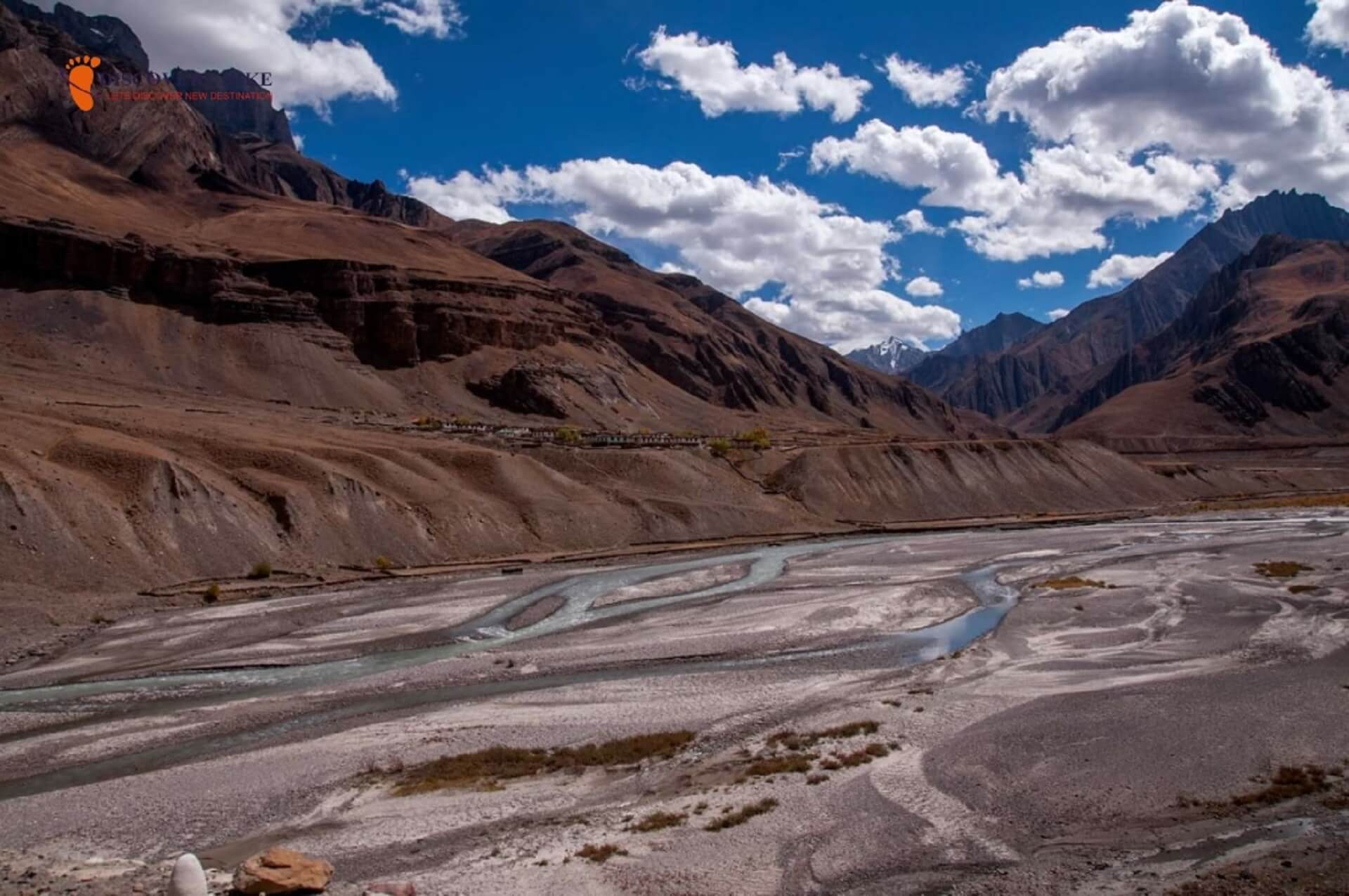
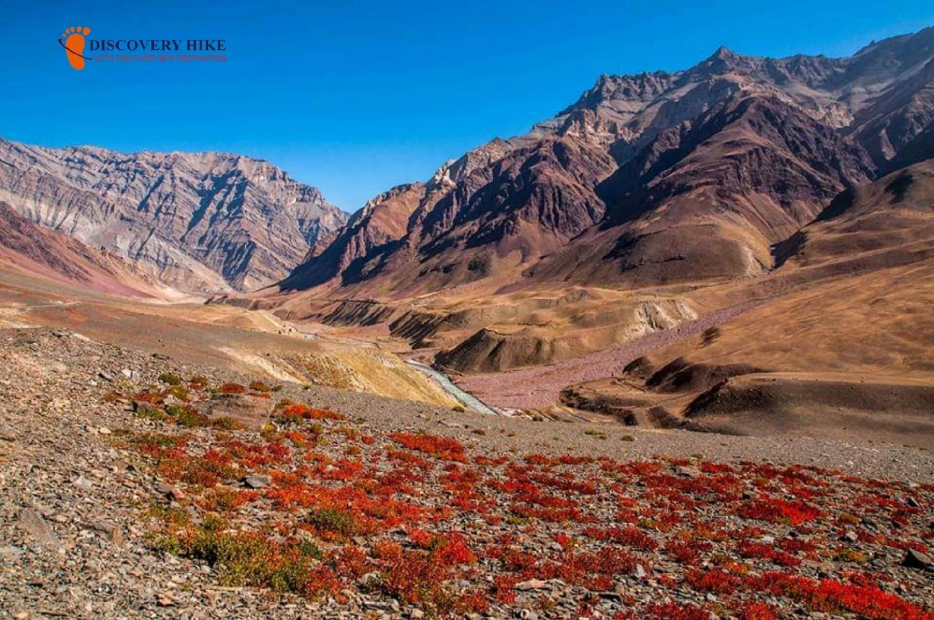
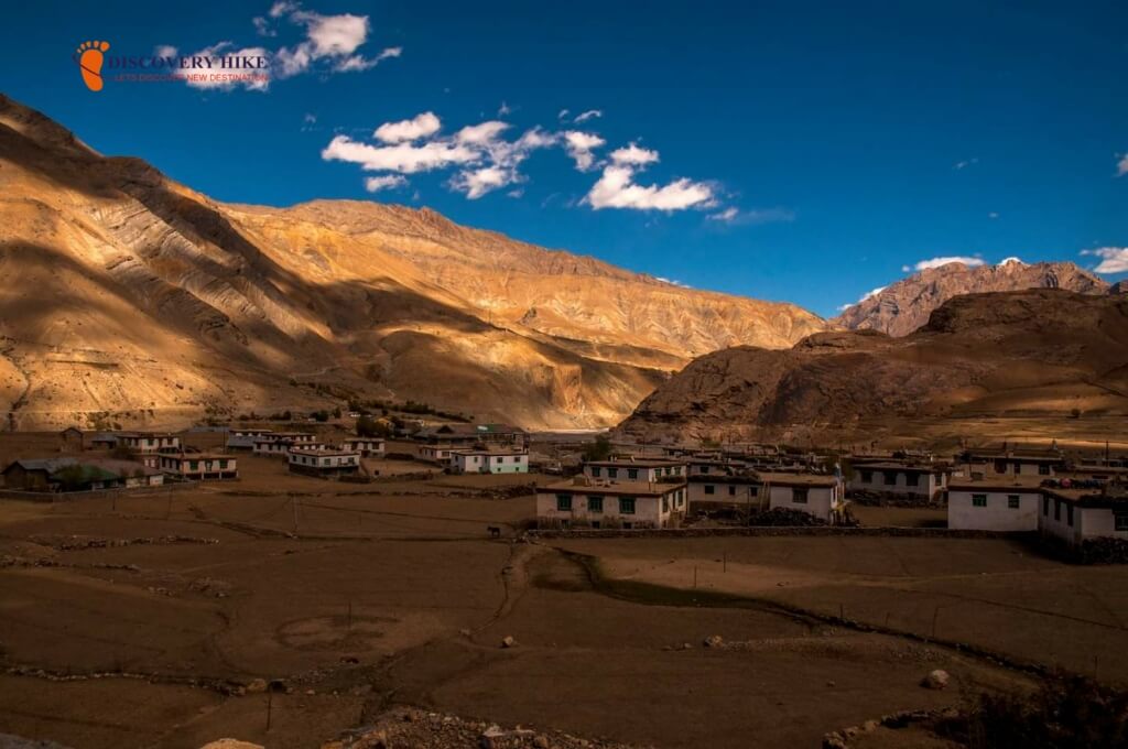
The valley is now traditional Spitian in appearance, dry except with patches of grass and scree. We start early in the morning and descend steadily along the left bank of the Pin River (as long as we remain to the true left of the river). We travel 13 kilometers to Chinpatta Maidan (4000 m/13120 ft). On the other side of the canal, the road leading to the Bhaba Pass for Kinnaur can be seen. As the Pin valley broadens out, the scenic abundance of colored mountains mesmerizes you. The path descends gradually along the river’s left bank until it meets Mud (3750 m, 12300 ft), the first village in the Pin valley, which is another 12 kilometers away. It will take about 10/11 hours to complete the trek.
Day 10: Departure from Manali
We take the road back to Manali via Kaza, Lohsar, Kunzum La to Chhatru, and then over Rohtang Pass to Manali on the final day of the journey. This is where the journey comes to a close.
subscribe Now
DETAILed ITINERARY
Day 1: Manali Arrival
By noon/afternoon, you should be in Manali (altitude: 1950 m/6400 ft). Our guest house will be either in Manali town or in Vashisht, which is 3 kilometres away. Vashisht has a shrine, which is known for its hot spring inside. After that, go for a stroll to the Jogini Drop (Vashisht). Guests are accommodated in a cabin or a guest house.
Day 2: Drive towards Barsheni and then Trek towards Kheerganga
Pick up in the early morning from Manali and drive to Barsheni (2200 m, 7200 ft) via Kasol and Manikaran. The distance is approximately 110 kilometres, and it will take approximately 4 hours to complete. From here, the trek begins. The trail ahead is a 9-kilometer hike through a beautiful forest to Khirganga's open meadow (2920 metres, 9580 feet). This is the hot spring where Lord Shiva meditated, according to legend. In the season, one should take a relaxing bath. It will take about 5 hours to complete the climb. In the tent for the night.
Day 3: Trek towards Tundabhuj
The 12 km walk to Tundabhuj (3400 m, 11150 ft) is fun, as we follow the Parvati river valley once more. The gentle ups and downs, as well as the passage through lovely grazing grounds and stretches of montane conifer woodland, give the trail the feel of a classy Himalayan trail. On sometimes, we will see the river on our left. The camping ground is located on the outskirts of a birch woodland. As we camp on the true left of Parvati, the Parvati river rambles through the gorge to our left. A sheer rock wall with five separate spikes jutting up from the other side of the channel. Legend has it that these are the five Pandavs, who are known as Pandu Shilla. We're going to set up camp for the night.
Day 4: Trek towards Thakurkuan
Today's hike will take you to Thakurkuan (3600 m/11800 ft). We're following the river's route. The trail gets challenging after a while, and we walk on a narrow rocky path. In 2014, the wooden bridge that crossed the river washed down, and since then, the track has followed the true left of Parvati all the way to Thakurkuan. We used to have to cross the river again over a hand-drawn Pulley Bridge, but that is no longer necessary. After about 2 kilometres, a wide vista opens up. There are many wild flowers in the panorama, including iris and poppies, to name a few. For the day, we set up camp in the valley. The distance is 6 kilometres, and it will take 3 to 4 hours to complete.
Day 5: Trek towards Odi Thatch
We continue down the river for the rest of the day. We cross a side stream over a boulder after a while. The pool is known as Chhota Pandu, and the traverse on the rock exposes the stream that runs 30 feet under it. Following that, we cross the main river by way of a massive boulder that spans the Parvati River. This is known as Pandu Pool and is a wonder of local engineering. The water will be on our right from now on, and we will really be in the real right of the river. After crossing the bridge, a climb begins immediately and lasts for an hour. When we hit the mountain's shoulder, we turn left and walk gently across a large alpine meadow. At the end of this meadow is Odi Thatch's campsite.
Day 6: Trek towards Mantalai
Today's hike will take us to Mantalai (4100 m/13500 ft), which is thought to be the source of the Parvati River. The trail is gradual at first along the gorge, but when the valley widens, so does the water rush. Because of the river's shallow flow, a swamp land stretches for around a kilometre. Chhota Mantalai is the name of the neighbourhood. A rock wall can be seen across the river at a distance. We abruptly leave the vegetation behind and join the glacial moraine and waste. The glacier's snout is easily visible. We follow a moraine ridge that dams the Mantalai Lake and ascend it. Every exhausted trekker would be awestruck by the vastness of Mantalai from the top of this mountain. We are greeted by a shrine, cairns, and flags.
Day 7: Trek towards Parvati base camp
Today has been a long and difficult day. We leave the camp early in the morning and travel down the valley after passing a side stream. As we scale a steep and steady slope, we hold to the left. This is a challenging segment. We turn left at the top of the climb and reach a rock and boulder section. Over boulders, we encircle the zone. Another icy stream gushing from the glacier is only waiting for us to cross. We reach the glacier's start after a final scramble up a steep slope. This is the glacier that originates from Parvati Pass's watershed. For the Parvati side base camp (5000 m, 16500 ft), we camp at the glacier's edge. The distance is 10 kilometres, and it could take up to 8 hours to complete.
Day 8: Trek towards Pin side base camp
Today we set off early in the morning through the vast open ice field that leads to the eastern pass, which takes 4 hours to enter. We must cautiously navigate the crevasses and frozen slopes. We see the glacial lake formation and snow-capped peaks while walking on the permafrost region. On the ice, there are a few crevasses that must be navigated. We ascend a steep rocky ridge and the final stretch to meet the Pin Parvati Pass (5300 m/17400 ft). The pass has a panoramic view of Spiti's peaks and valleys. We make our way down from the pass, first on snow and ice, then on loose scree.
Day 9: Trek towards Mud
The valley is now traditional Spitian in appearance, dry except with patches of grass and scree. We start early in the morning and descend steadily along the left bank of the Pin River (as long as we remain to the true left of the river). We travel 13 kilometres to Chinpatta Maidan (4000 m/13120 ft). On the other side of the canal, the road leading to the Bhaba Pass for Kinnaur can be seen. As the Pin valley broadens out, the scenic abundance of coloured mountains mesmerises you. The path descends gradually along the river's left bank until it meets Mud (3750 m, 12300 ft), the first village in the Pin valley, which is another 12 kilometres away. It will take about 10/11 hours to complete the trek.
Day 10: Departure from Manali
We take the road back to Manali via Kaza, Lohsar, Kunzum La to Chhatru, and then over Rohtang Pass to Manali on the final day of the journey. This is where the journey comes to a close.
subscribe Now
Get Quote
DEPATURE DATE
Call- +91-8979108941 | +91-9458118063
Call- +91-8979108941 | +91-9458118063
Call- +91-8979108941 | +91-9458118063
Call- +91-8979108941 | +91-9458118063
Call- +91-8979108941 | +91-9458118063
COST INCLUSION
-
Pick and Drop Service from mentioned location
-
Fees for the guide and the chef
-
Camping facilities' rent
-
Entrance fees to the forest
-
To transport camping gear, a porter and mule are required. Please keep in mind that personal baggage can be borne by mules and/or porters for a fee
-
From the first day's dinner until the last day's brunch, both of the meals are vegetarian
-
Throughout the walk, you'll be staying in a tent or if possible, then in a guest house
COST EXCLUSION
-
No pickup and drop point from/for your hometown
-
Personal costs include things like tips, personal medications, and conference calls, etc
-
Apart from what is mentioned above, some transportation assistance during the trek
-
Porters/mules can carry personal luggage weighing up to 12 kg per bag per person for Rs 350 per day per bag
Frequently asked question
- Footwear: The trekking boots which must be waterproof and snow proof, normal boots, floaters, and woolen socks.
- Backpack: (50 ltr), Daypack (20-30 ltr), Duffel bag.
- Clothes: Jacket and trousers that are both waterproof and breathable. Jacket (synthetic or down feather fleece), synthetic insulated trousers, poncho, sweatshirt, inner thermal (upper & lower), fleece, t-shirts, cotton trekking pants, shorts
- Season wise Clothes:
- Hand and head protection includes liner gloves, bandannas, sun hats, woollen caps, and face masks, among other things.
- Accessories: Sunglasses/goggles, anti-glare lenses, water bottle, hydra bag, and headlamp with spare bulb and extra batteries are all recommended.
- Trekking Gears: Toolkit for an emergency. Sunscreen, a toiletry pack, water purification pills, Ziploc packs, ear plugs, first-aid kit, and the necessary medications are all recommended.
- Camping Equipment: Sleeping bags of lining (extreme -5 to +5 Celsius if you have one), trekking sticks, and so on.
- Warm top/light micro fleece pullover/full sleeve T shirt – 2/3
- Water resistant/repellent trekking pants with an inner lining for added warmth- 2 High-quality windproof/water-resistant outer shell (jacket) with a proper hood
- Thick Fleece / Full-sleeve Woollen Jumper, Down Jacket with at least 600 fill capacity Innerwear with a thermal component (upper and lower)
- Woolen hat, inner fleece gloves, and outer water-resistant gloves
- 4–5 pairs of thick woollen socks and standard socks, scarf/muffler (optional)
- Waterproof Trekking/Hiking shoes with a thick heel and high ankles that are comfortable to wear. Sneakers/sport shoes are ideal for camp.
- Poncho or raincoat. A small, light-weight towel
- A hydration pack and an insulated water bottle (optional)
- Sunglasses with UV cover and the potential to cut light, as well as a cap or floppy hat to shield the strong sun off your skin (important when traversing through snow)
- Trekking pole or sturdy walking stick Lip Balm, Sunscreen Lotion
- Flashlight / torch (with extra batteries) Medications, if any special prescription is needed Toiletries for personal use
- Carry a rain cover over your luggage • Day pack/small bag that you can carry on your back all day to keep your essentials in
- Keep a few poly bags or plastic containers in your bag to place your things in if you need to in case of heavy weather.
Personal Medical Kit (MANDATORY FOR ALL)
- 10 Diamox tablets (to prevent AMS)
- Nifedipine – 5 pills Dexamethasone – one strip
- 6 tablets of Crocin (fever)
- 4 tablets of avomine (motion sickness) 4 capsules of Avil 25mg (allergies)
- 4 tablets of Combiflam (Pain killer)
- 6 tablets each of Norflox TZ and Lomofen (diarrhea) 10 tablets of Digene (acidity)
- 10 Omez/Rantadine capsules (antacids) 3 to 5 metres of crepe bandage
- 1 tiny roll of gauze 10 strips of bandage 1 small roll of cotton 10 packets of ORS
- Moov spray Betadine or other antiseptic cream (aches, & sprains)
- If you're vulnerable to knee injuries, you should wear a knee cap. Powder with antifungal properties
- Cancellation: If a trek is cancelled at the last minute due to a natural disaster or unforeseeable circumstances (such as floods, earthquakes, landslides, attack, or bandh), Discoveryhike will have a trek voucher for the full number. The voucher can be used for the same or a different trek over the next year.
- In case you wish to cancel the trek, then please be aware of these things:
- Cancellations made within 30 days of the trek's launch date will include a complete refund.
- If you cancel within 30 and 20 days before the hike, you will get a 50% refund.
- There will be no refund if you cancel less than 20 days before the trek begins.
- Please keep in mind that if you get a refund, there will be a reduction of 4% (Cancellation charges) from the overall amount you pay. In addition, if you purchased trek insurance, you would not get a refund.
- Discoveryhike assumes no responsibility for any malfunction or injury to your clothes, supplies, or other belongings while on the trek. The trek fee covers all expenses associated with the trek from start to finish.
other Treks